

|
|
Before the wheels start grinding dust on the back roads in pursuit of storms I would like to do a quick back track to a few days earlier on July 25th. On that particular day I was soaking up the warm rays of the sun on a lovely beach at Portballintrae in Co. Antrim beside the glorious Atlantic Ocean when a formation of ice crystal-rich cirrus clouds passed across the sun, when this happens sunlight gets redirected through ice crystals which act like tiny prisms which bend or refract light away at various angles while splitting white light into its component colours just like a spectrum, the result is known as an atmospheric optics display in the form of halos and arcs of light which can be seen in proximity to the sun. Most people miss them as it goes against instinct to look in the sun's direction however if you get into the habit of blocking the sun's glare with your hand or by using a building then you will dramatically increase your chances of seeing something special. These ice halo optics come in many forms from common halos to more rare specimens which require a greater depth of skill and knowledge to catch in the act, I have been observing optics displays for as long as I have been into astronomy however there are only a few times that I will actually record a display on camera these days unless the display is rare or considerably photogenic.
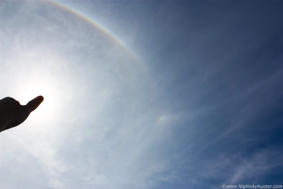 |
This day satisfied both categories and put on an impressive show in the afternoon sky for over 1.5 hours so I got busy observing, taking images, and even some video footage. I really needed a 10mm wide angle lens or even a fish eye to take everything in however I had to do with my 18mm kit lens and make the best of what I had. In the above image I blocked the sun with my outstretched thumb and placed the sun to the far L of frame so attention can be drawn to the region adjacent to it. Above the sun was a remarkable highly curved upper tangent arc (UTA) with impressive yellow, white, and blue colours, below this was at faint 22 degree halo and outside of which was a circumscribed halo. Near image centre is a sundog or mock sun (parhelia) with the same colours as the UTA, this sundog was located further than the typical 22 degree parhelia. Next was a curved parhelic circle which began at the sun and extended through the halo, sundog, and out across the sky beyond the frame into the N, this was the showpiece catch of the day.
 |
This was facing towards the anti-solar point, by that I mean the sun was behind me and I was observing the sky directly opposite towards the N where the parhelic circle can be seen as a white ring crossing the frame where it continued around the E sky and returned once again to the sun, in effect I could rotate 360 degrees and follow this huge ghostly ring in the sky, this is what's called a 360 degree or complete parhelic circle. I had only seen a partial specimen in the past during the night from the moon but never before had I observed a complete parhelia in the daytime sky, also of interest is a colourless enhancement on the ring to the R of centre called a 120 degree parhelia, both of these are rare specimens for optics hunters, at least rare from our latitude. Optics are a thrilling and complex field of observational sky watching to get involved in, I cannot do justice to the subject here so I will pass you on to the website of one of the most famous atmospheric optics experts in the world - Les Cowley.
 |
Going back in time a little further to June 2nd/3rd on the hunt for Noctilucent Clouds or NLCs. Every year these mysterious night shining clouds appear at unpredictable intervals in the night sky in N. Ireland, the typical season runs from late May to early August with the best displays possible on the weeks either side of the Summer Solstice. NLCs have provided me with wonderful visual thrills and photogenic wonders every year so I was looking forward to the 2012 season with great excitement. The season surprised everyone by starting early in late May with regular displays which seemed to decrease in frequency as the season advanced and unfortunately no major sightings where made from UK/Ireland, this was mostly due to the fact that we have just been through one of our worst Springs and Summers on record with an abundance of cloudy weather in conjunction with greatly heightened solar activity which turn NLCs into a shy phenomena until the years of solar minimum return once again. As I type this near the end of the current season my 2012 NLC tally currently sits at 5 nights of observation between late May and early August during which period I experienced my worst spell of back to back cloudy nights since comet C/2006 P1 McNaught back in Dec-Jan 2007.
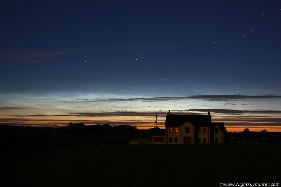
Only one night of NLC hunting stands out and that was when the above image was taken which was also my first and best NLC catch of the season so I do have fond memories attached to it. This was after midnight in the Maghera countyside, I was parked on a grass verge near the top of a hill where I took this image from, as you can see the growing NLCs looked attractive stretching across the twilight midnight sky with that lonely country house in view and judging by the glow in the upstairs windows it was likely that the occupants were in the process of retiring to bed for the night, perhaps reading a book and unaware of a special phenomena taking place in the sky behind their home. The pearly white colour and the blue upper canopy are all part of the NLC display with bright star Capella and 'The Kids' clearly visible in the constellation of Auriga, this is where the majority of NLC displays will reside each Summer. The display was still growing and although it would never become stunning it was still a pleasing early season performance so I was more than happy with it. In more technical terms I recorded it at 15 degrees high, 100 degrees in azimuth, type 3 brightness with type Ia veil, IIa and IIb bands, with small scale whirls and lacunous holes.
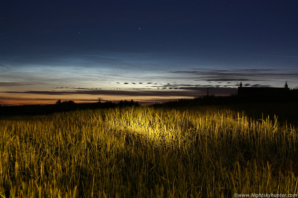 |
This was 02.00 in the morning as the NLCs peaked with plenty of delicate structure and the classic electric blue colour with short type III waves (herringbone) formations forming rapidly within these wonderful clouds. NLCs are literally on the edge of space some 82km high within the Mesosphere where meteors enter the atmosphere, in fact, the latest studies on NLCs show that they are actually composed of tiny meteoritic dust particles, the kind found in meteoroids, some of which may have once belonged to asteroids so these clouds are certainly what you would call space weather. I found this lovely wheat field and quietly wandered into it hoping not to rouse the attention of an irate farmer and managed to get some nice exposures of the NLCs glowing over this beautiful field, I used a torch to bring up the foreground which worked quite well although it's not as easy as it might seem as there is a certain art to this 'light painting' which can only be learned through trial and error.
I can tell you it was magical standing in this field during the early hours of a Summer's night with stalks of wheat up to my waist with the scent of crops rich in the air while this NLC display did its thing against the majestic twilight sky. The night was warm and musky and at times I felt like I could have stood in a t-shirt and to top the experience off the massive dark form of an Owl silently swept across the sky in quest of prey, it swooped over the crops and close to my head and as I gazed aloft I could see its mighty dark wings and body against a backdrop of bright stars, this really was the icing on the cake because every NLC season connected me with this Owl and this season did like-wise so all was well. Movement at the back of the field brought me back to my senses, I couldn't see the source but the sound was real and random while getting closer, perhaps it was a farmer with a shotgun, a Cow or a Fox, either way I didn't stick around to find out, I returned to the car and relocated then I was back in bed by 03.00, a fun night.
 |
Now back to July 30th when there was a risk of convective showers and thunderstorms in a cold unstable maritime air mass from a NWly flow with only low instability, however there would be good solar heating and a trough passing through which was encouraging but other than that it didn't look very exciting with only 200+ CAPE during the morning and peaking at 400 in a small zone later in the afternoon, I wasn't excited about this and blew it off as just a day of showers and bubbling towers with no potential for organisation. I was taken completely by surprise when I checked the radar that morning and saw that strong cells had formed at dawn and moved SE across the Atlantic Ocean off the Antrim coast while clipping the NE side of N. Ireland as they traveled over the North Channel, they were going strong from 05.30 to 10.00 sporting red and white radar echoes with c-g lightning, that was a shock because to last that duration of time they had to be organised and I would bet they could have produced waterspouts too, oh how I wish I had been at the coast to have seen them, perhaps the atmosphere had changed overnight, there must have been convergence and shear at work today.
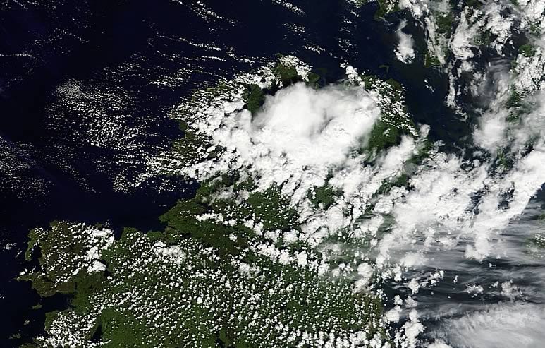
The sky outside during the early morning looked like it was trying and I began to get a good feeling with the classic white towers going up against a rich blue sky. By late morning another radar check showed significant development when cells formed over the ocean to the NW of Ireland then moved inland over Co. Donegal where they exploded to life producing lightning and big hail stones, I looked out my front door and could clearly see the big anvil in the NW sky while it was still over Donegal!, the next radar update showed the storms forming into a large cluster and intensifying as they began moving SE towards mid Ulster so I made this my target for the day and what made this even better was that they where heading for me so I just needed a good viewing spot. The above high resolution satellite image was taken at noon showing that big storm cluster over NW N. Ireland, at the time the image was taken it was heading for the W Sperrins and would soon be at my doorstep, that large white mass is the storm, you can see the stronger updraughts punching through, the clear sector ahead of it was where I was located and about to become engulfed by the cluster.
 |
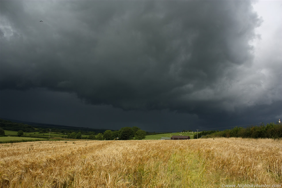
I needed to hurry before the storm arrived, I always like to be out and waiting when cells are coming in because only then can you take advantage of any available light and have time to observe and shoot any decent structure like shelf clouds and precip curtains. I grabbed my gear, got in the car, and drove to a country location nearby just outside Maghera and pulled over near a gate adjacent to a field. The storm was taking up the entire skyline and at first glance it seemed weak with fuzzy anvils and a dense wall of white cumulus clouds, however as my eyes adjusted to the intensity of the clouds I spotted something lurking in the distance which got me excited. Under the white mass of cloud was a region of dark blue precip falling in a sheet and tucked up ahead of that precip was a dark solid threatening cloud formation running along the leading edge of the storm, this was a shelf cloud or 'Arcus' which can be very photogenic indeed so I needed to find a good foreground however I had to think fast as the formation was almost on top of me. In an instant I recalled that NLC night back in early June and knew that was the place to be so I drove on up the road onto high ground near the top of a hill in the countryside and pulled the car into a space beside a line of trees with barely enough room for the car to fit but I just made it and no more. I made sure the car was locked then ran across the road and took a few images while resting on the gate to the field, the storm was already here!
 |
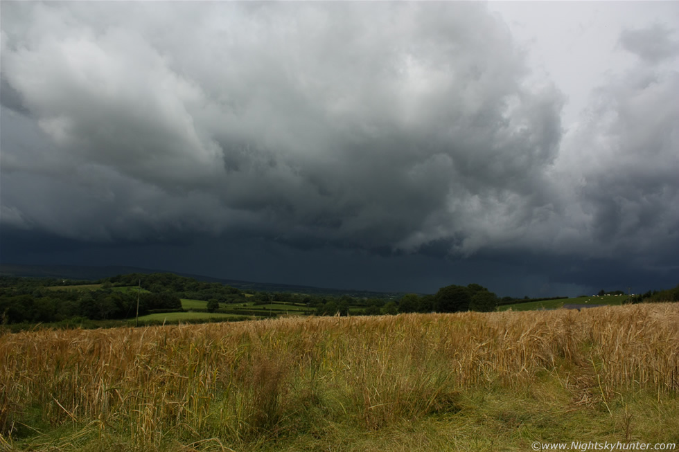
I quickly climbed over the gate and ran into the field to get the full experience, it was hard to believe that this storm was producing lightning over Donegal over an hour ago and now here it was dominating the Sperrin mountains and about to pass over my home town of Maghera. This is looking W to NW as the storm approached with dramatic dark cloud structure while overhead and behind me the sun shinned proudly oblivious to what was coming and in doing so lit up this entire field of wheat in its full glory making for the perfect storm scene.
 |
This early afternoon made my entire Summer storm season photographically speaking. Spring and Summer had been active months in N. Ireland for tornadoes, funnel clouds, and numerous hail showers and big thunderstorms however the very best of this action was at locations a considerable distance from me and on days when no tornadoes were forecast, furthermore on days when storms were forecast there was a lack of shear and convergence so none of the storms had much organisation, I chased on many days and put in alot of miles and pretty much whatever money I had was used up on petrol so I could get out and chase storms in the hope of catching something photogenic which usually happens every year, however 2012 was a hard nut to crack, at least it was for me. I had intercepted storms, caught two funnel clouds, observed rotation and was awe struck by the massive single cell storms over Lough Neagh earlier in the year however I hadn't got the meaty structure image over land which I was looking for. Every storm photographer knows what they want to catch and for me, among other things, I have always been a fan of meaty gust front features, the more solid and darker the better and deep down I couldn't settle myself until I caught one this season, only then could I concentrate on other things.
On July 30th nature presented me with precisely what I was looking for and I can tell you I had a big smile on my face as I stood there with shutter button going like crazy shooting this incoming storm, I was in my element if you will excuse the pun. It was a truly wonderful experience standing in the middle of an ocean of wheat shinning like gold with the proper smell of Summer in the air and the hot sun burning the back of my neck as this black gust front got closer with every minute, I truly love storms for moments like this, I only wish I had someone there to take an image with me standing in the foreground, it would have made for a great profile picture. Nature really is a superb artist to produce such a dramatic moment, it's not often that one gets incredible light like this I can tell you, I've gone through many hundreds of weather images this year already just to get one golden moment like this.
 |
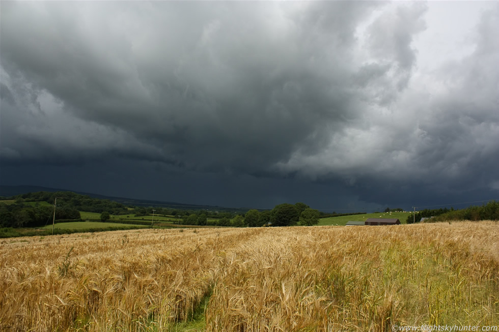
The sky was getting so dark that I had to use a slower shutter speed to get more light and pick up the cloud structure, balancing the exposure between field and sky was tricky however I figured it out in no time. That line of solid dark cloud is the shelf cloud or gust front of the storm, this formation is caused by cold dense air descending from the storm's outflow as it pushes ahead of the rain core and lifts warm air upwards much like a cold front would do, this rising moist air then manifests itself as a linear cloud structure along the leading edge of the storm, this is what's known as outflow feature and they tend to look very menacing, they come in all shapes and sizes however you will know one when you see it as they usually mean trouble, a shelf cloud often precedes heavy rain, hail, gusty winds, thunder and lightning, in severe storms and squall lines those gusts of wind can damage structures and it's not uncommon for them to produce brief tornadoes too.
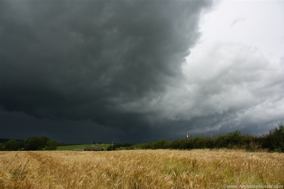 |
The storm blocked out the entire skyline from N to S and much to my delight the sun stayed out to work its magic on the wheat field the entire time. The structure at this point was really impressive along the N section of the shelf cloud with numerous complex chunks and nasty looking shapes downwind of the main precip area with the first half of the storm bathed in white and grey tones while the second half was a striking dark charcoal colour.
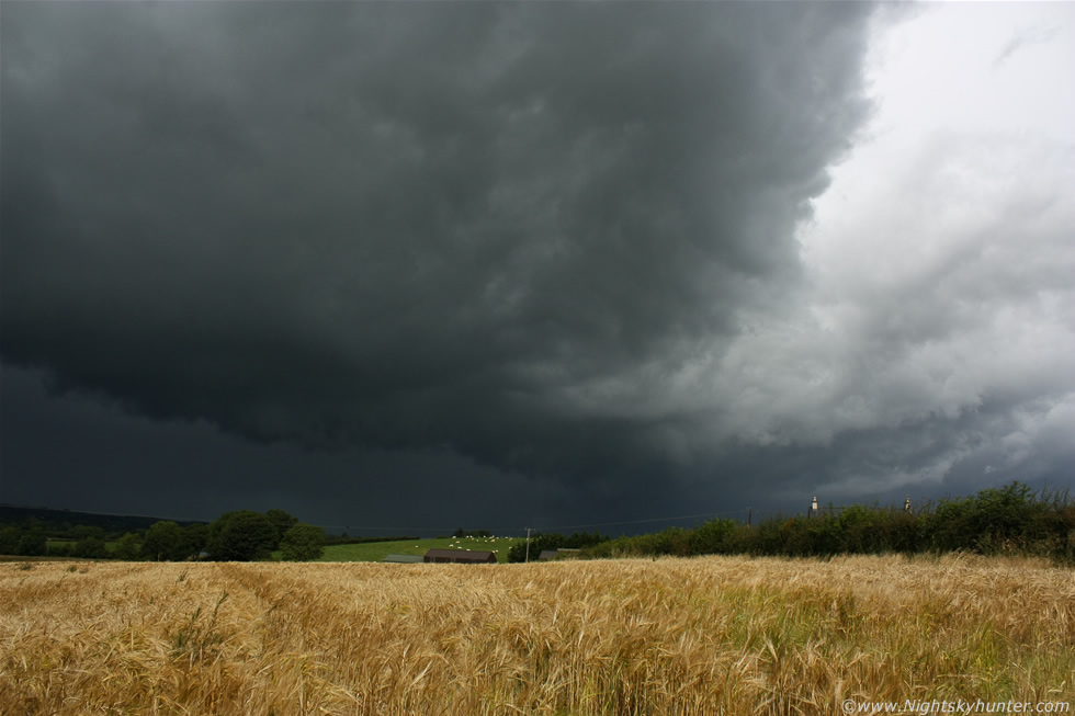 |
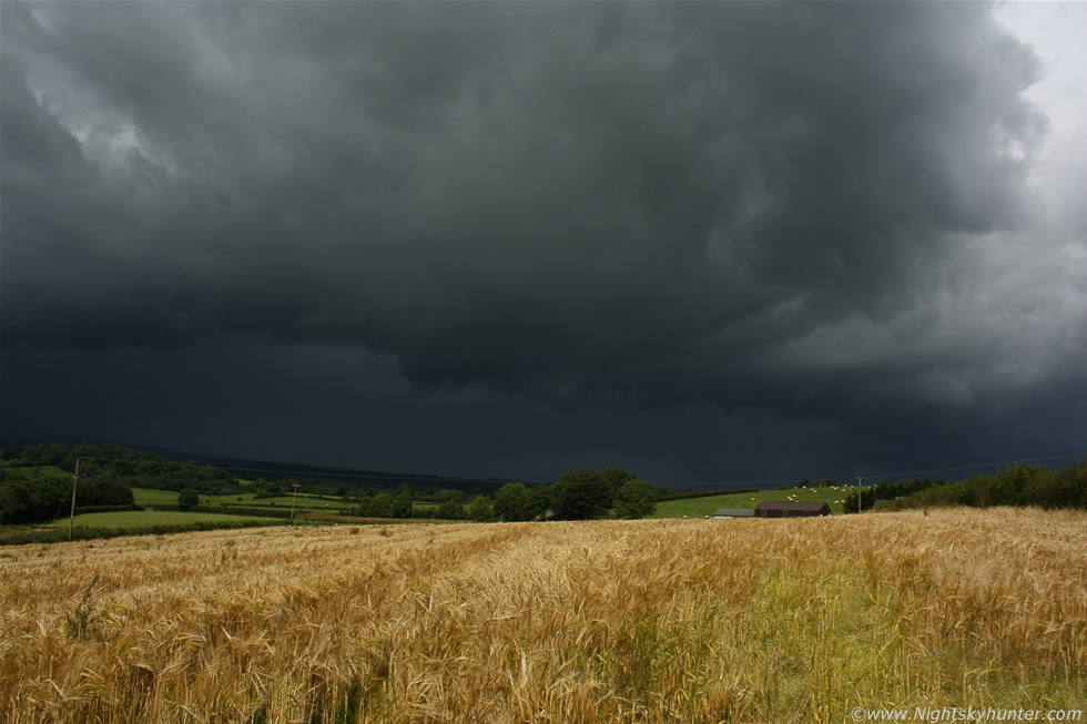
Another image of that same structure this time showing more of the dark section of the storm, I took alot of images at this point and even a few short video clips, the latter were very rushed and shaky, I should have mounted my video camera on a tripod and shot the entire event which would have made for a very cool clip, if only I had thought of it at the time. The still and silent wheat stalks began to stir as a breeze picked up which strengthened as the outflow hit causing the wheat to wave and protest as the cell's stronger gusts of wind agitated the field with stalks leaning over to the E by their hundreds like nature's hairdryer on blow dry.
 |
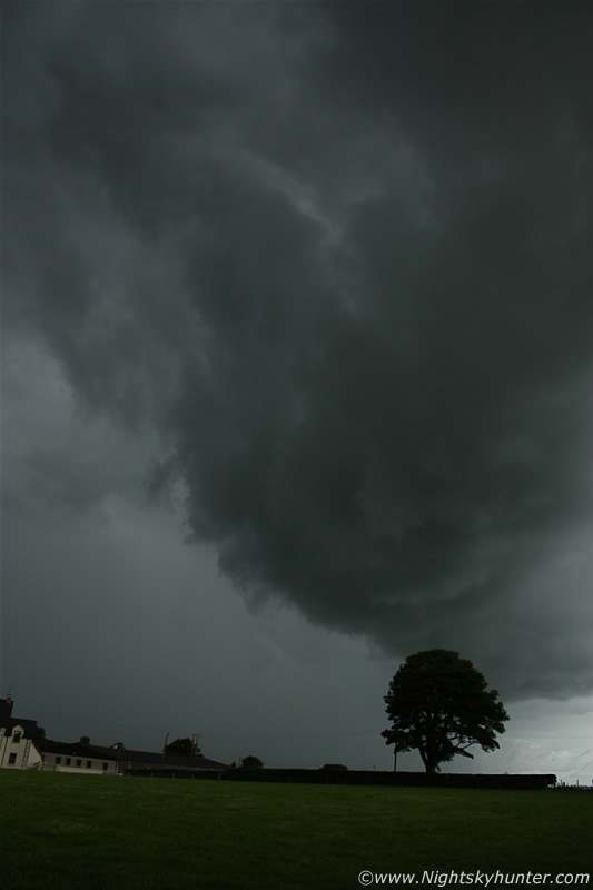
The N side of the gust front curling nicely along the leading edge as it blew across the countryside turning Summer to Autumn in an instant, or at least it felt like that with a sudden temp drop, darkness, and big drops of rain sending the Cows and Sheep running for shelter. Recognize this scene?, it's the same place where the first NLC image was taken from.
 |
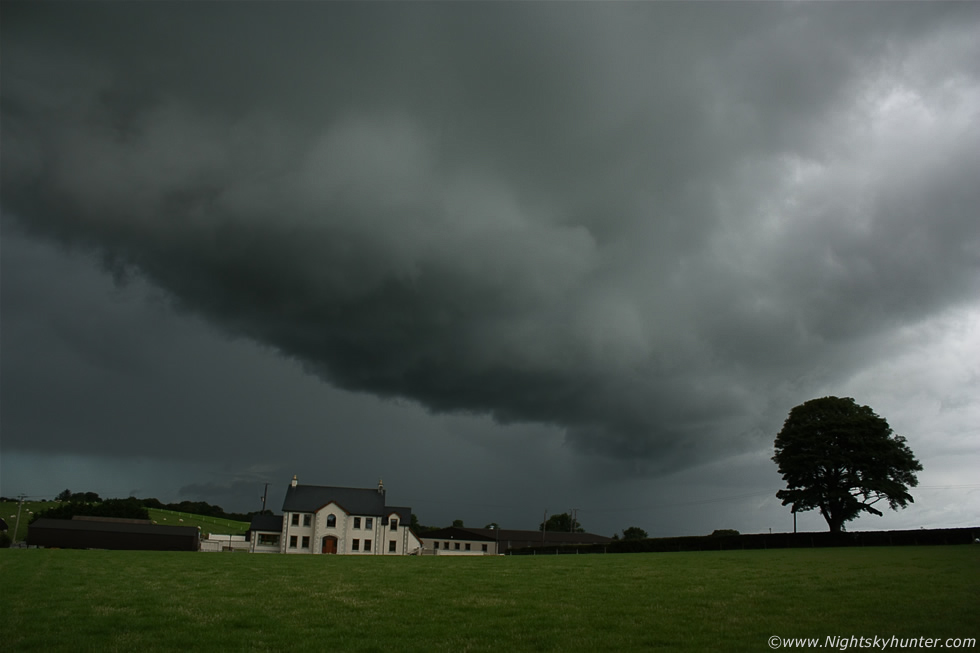
18mm portrait shot of the guster doing its business, it was very solid with good looking structure and at one point a funnel shape could be seen forming behind the leading edge, I didn't see any rotation so perhaps it was just a chance shape moulded from the shelf, or maybe a brief shear funnel, who knows, in any case you can briefly see it on the video clip towards the end. I took shelter in the car as wind, rain, and hail stones hit then when it eventually passed over I could see the back end of the storm taking up a large area of the E sky with a nice white anvil in full sunshine with lush green fields under sun beams contrasting with the dark blue thundery precip core below which made for quite a scene. The storm cluster continued moving SE with very intense radar echoes, the line sparked up again with more lightning to the W of Lough Neagh and SE Omagh before it reached the border. Quite a dramatic day indeed and it all happened before lunch time and with a total chase distance of 1 mile, it doesn't get any better than that!.
Video clip of the storm and wheat field, you can really appreciate the wonderful light along with the gust front passing over towards the end, this looks alot better on the original HD footage I have.
Video clip of the optics display over Portballintrae showing the halo complex around the sun and me panning around a full 360 degrees showing the complete parhelic circle. So what's next?, my mind is as focused as ever on storms, funnels, tornadoes, meteor showers, snow, geomagnetic storms and great comets. I'm very much looking forward to getting the camera shooting what could be a very action packed second half of this year, thanks very much for reading.
Martin McKenna